|
| Peermede |
|
 |

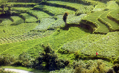
Location: About 40 km from Kumily, Idukki district, Central Kerala.
Peermede is a lovely hill station at 915 m above sea level. It is an
ideal retreat in the Western Ghats and a choice break for tourists en
route to the Periyar Tiger Reserve.
Sprawling gardens of tea, coffee, cardamom, rubber and eucalyptus
lying side by side with natural grasslands, pine forests and
waterfalls make this an ideal summer resort. The summer palace of
Rajas of erstwhile Travancore is today an important monument here.
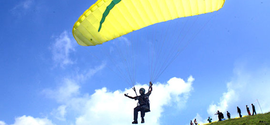
Peermede and its surroundings are suitable for trekking, cycling
and horse riding. Kuttikanam a place for adventure tourism and
trekking is just 3 km from Peermede.
Another attraction here is Thrissanku Hills, about 4 km away. The
rolling hills, the lovely landscape and the gentle breeze make this a
choice spot for long walks. The hills offer a breathtaking view of the
sunrise and sunset.
|
| Vagamon |
|
|
Have
you
visited beautiful, green Vagamon Are you thinking, "In a
green country, what's the attraction of yet another verdant
spot" Well, the point is Vagamon is not just any other verdant
spot. Of course, you can get grassy hills, velvet lawns and cool
mountain air in many other places but not the Vagamon kind; not just
this exciting blend of religious mysticism and European
legacy.
Like a lot of other
beautiful things in life, Vagamon too has to be
experienced,
not read about or its stories merely listened to. What
you've got to do is get yourself some means of transport, head
straight for Idukki district and then on to Vagamon. Once there, try
taking off your shoes, closing your eyes and just listening to
Vagamon.
And when you're through with the
mystic getting to know session, you could take a trek across the
chain of three hills - the Thangal hill, the Murugan hill and the
Kurisumala, important for Muslims, Hindus and Christians
respectively.
And don't miss
the nice, little dairy farm of the Kurisumala
monks.
Getting
there:
By road: 25 km from
Peermede, the famous
plantation town.
Nearest railway
station: Kottayam
which is about 75 km from
Peermede.
Nearest airport: Cochin
International Airport, about 150 km from
Peermede. |
|
| Nelliyampathy |
|
|
From the town of Nenmara in Palakkad
district, the cloud-caressed peaks of the majestic Nelliyampathy hill
ranges are a sight to behold. The height of the hills ranges from 467 m
to 1572 m. To reach Nelliyampathy, one has to take the road starting
from Nenmara that proceeds to the Pothundy Dam. There are about 10
hairpin bends that have to be negotiated on the way to Nelliyampathy.
The Pothundy Dam is a picturesque locale with facilities for boating
and is a nice option as a picnic place. As the Ghat road winds its way
up to Nelliyampathy, at certain places there are viewpoints from where
the vast stretches of Palakkad district are visible with its extensive
paddy fields forming a verdant carpet. It also offers a splendid view of
the Palakkad Gap, which is a geographical phenomenon in the Western
Ghats formation in this region, bringing into view, parts of the
adjoining State of Tamilnadu.
On the way up, those interested
in bio farming can take a close look at the privately managed farms and
also vast expanses of tea estates managed by different plantation
companies. The hills of Nelliyampathy are also well known for its orange
cultivation.
Privately owned hotels and resorts are located at
various points, as one goes up the hills of Nelliyampathy. The
bio-farms located here are a major landmark as one proceeds up before
reaching the topmost point at Palagapandi estate. The estate has a
quaint bungalow, built during the period of the British rule in India,
and has now been converted into a private owned resort. At Kaikatty, a
community hall is available, which is usually used as a base by those
interested in trekking.
Not far away from Palagapandy is
Seetharkundu where one can have a fantastic valley view, and a 100 m
high waterfall providing an added attraction. From Palagapandy, one can
trek or go by jeep to reach Mampara; another breathtaking vantage point
at Nelliyampathy. The area in and around Palagapandy estate has tea,
cardamom and coffee plantations with adjoining hills allowing one to
catch a glimpse of the wildlife in the form of Indian gaur, elephants,
leopards, giant squirrel etc. and is also a paradise for birdwatchers.
Getting there:
Nearest railway station: Palakkad, about 52 km from Nelliyampathy.
Nearest airport: Coimbatore, about 55 km from Palakkad.
|
|
|
|
|
|
|
|
| Rajamala |
|
|

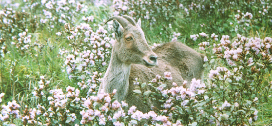
About 15 km from Munnar, the famous hill station of Kerala, is the
beautiful Rajamala. The natural habitat of the Nilgiri Tahr (Hemitragas
hylocres),
the Eravikulam - Rajamala region is now home to half the world Tahr
population estimated at around 1300. But the Tahr is only one of the
reasons to make a visit to Rajamala. The picturesque beauty of this
mountain will make you want to tent here forever!
Accessing Munnar:
By road:
Distance from Munnar to some tourist centres
Goa: 930 km, Chennai: 600 km, Malampuzha: 230 km, Kodaikkanal: 195 km,
Kumarakom: 160 km, Top station: 34 km, Anamudi: 20 km.
Nearest railway station: Kottayam railway station, 142 km away.
Nearest airport: Cochin International Airport, 130 km away and in neighboring Tamil Nadu, Madhurai
Airport, 142 km away. | | | |
|
| Pullumedu, Idukki |
|
|
The
winding journey to this hill along the Periyar River, offers a
stunning view of hills draped in lush greenery. Velvet lawns and rare
flora and fauna add to the beauty of Pullumedu. The famous Sree
Ayyappa Temple at Sabarimala and the Makara Jyothi illuminations at the
shrine are visible from here.
Accessing Pullumedu:
Location: 43 km from Thekkady, 26 km from Periyar.
Pullumedu can be accessed only by jeep. Since it is part of the
restricted forest zone, special permission to visit has to be obtained
from the Wildlife Preservation Officer, Thekkady Ph: 322027.
The Range Officer, Vallakkadavu.Ph: 352515.
|
|
| Mattupetty |
|
|

Cradled by the undulating
plantation hills of Munnar, and not far away from the Anamudi peak is
Mattupetty. Situated in the famous hill town of Munnar, Mattupetty located
13 km from Munnar is situated at a height of 1700 m, and is a delight for
nature lovers.
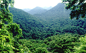
Mattupetty offers many fascinating sights to
relish. Besides the lush green tea plantations, and the rolling grasslands,
the Shola forests in and around Mattupetty are ideal for trekking and are
habitat to a variety of birds. Rivulets and cascades crisscross the terrain
here, which again adds more attraction to the
place.
One
of the main attractions in Mattupetty is the beautiful lake, and the
Mattupetty Dam, which are ideal picnic spots. The District Tourism Promotion
Council (DTPC), Idukki provides boating facilities in the Mattupetty Dam.
Speed launch, slow speedboat and motorboats are available on hire. Other
nearby places of interest includes the picturesque Kundala tea plantations
and the Kundala
Lake.
Of all the main attractions at
Mattupetty is the dairy farm, run by the Indo-Swiss Livestock Project. The
dairy farm is a unique one of its kind with several varieties of
high-yielding cattle being reared.
Getting
there:
By road: Mattupetty is just a 13 kms drive from
Munnar.
Nearest railway station: Ernakulam, about 130 km from
Munnar.
Nearest airport: Cochin International Airport, about 110 km
from Munnar.
| Neelakurinji bloom |
|
|
Kerala
is blessed with many natural spectacles and among them is a unique
canvas that gets unveiled every twelve years in God's Own Country.The
phenomenon of once in twelve years occurring on the fabled hills of
Munnar is attributed to the blooming of Neelakurinji or
passionately called by botanists as 'Strobilanthes kunthianum'. The
flower with 40 odd varieties bloom mostly in shades of blue, and thus
in its name Neela in the local language stands for the colour blue and Kurinji the local name for the flower.
This year, the hills of Munnar once again have welcomed Neelakurinji
on to its bosom after a period of twelve years.Revered by the local
tribal community and admired by visitors to these enchanting hills, the
blooming of Neelakurinji usually starts from August and would last up to October.
Once in Munnar, you may locate the magical blooms of Neelakurinji
at Kovilur, Kadavari, Rajamala, Iravikulam National Park, which is
home to the endangered mountain ungulate- the 'Nilgiri Tahr' and at
other places in and around Munnar. Nature lovers and travelers have
already started heading for Munnar to savour in this once-in-twelve-year
phenomenon.
It is an ethereal experience to stand amidst the sprawling blooms of Neelakurinji. The Neelakurinji
plant shows variation in height according to the elevation of the land
from the sea level. Usually shorter plants (about 2 ft) are found at
the high elevations, while taller ones (about 5 to 10 ft) are seen at
lower elevations.
Many tour operators, adventure clubs etc.
organise trekking for visitors to reach some of the best locales in and
around Munnar for seeing the grand spread of Neelakurinji.
Getting there:
Nearest railway station: Ernakulam, about 145 kms away.
Nearest airport: Cochin International Airport, about 110 kms away.
|
|
| Vattavada |
|
|
This month check out a less explored entity of Munnar, the much sought
after hill station in Kerala. Located about 45 km east of Munnar is the
serene village of Vattavada. At Vattavada, in comparison to other
regions in Munnar, instead of tea plantations, it is the predominance
of vegetables that occupy the terraced slopes and valleys of Vattavada.
The scenic hilly tract of Vattavada is at an altitude of 6500 feet
above sea level, and is a refreshing experience, which is yet to come
under the constant gaze and the footprints of visitors. The place
receives plenty of sunshine and the winter temperatures never dip below
unbearable levels. Besides the slopes of vegetable fields, one could
also find forest patches, interspersed with eucalyptus and conifers.
The area also teems with bird life and also other winged beauties like
butterflies in various colour, size and shape.
Vattavada could be taken for a place significant for trekking. Here, an
avid trekker would get options to explore many adjoining locations.
Some of the trekking routes starting from Vattavada include the ones
going to Kodaikanal, Top Station, Mattupetty, Kanthaloor and
Meesapulimala. Most of these treks offer enough excitement in terms of
negotiating the terrain as well as enjoying the floral and faunal
wealth on its course. Visitors could also engage in activities like
mountain jeep safari, mountain biking, jungle camping etc. offered by
private operators in the region.
The local populace of Vattavada has a significant number of tribals.
Their way of life, art forms, language, natural remedies are some of
the other interesting aspects that could be of interest to visitors
coming to Vattavada.
Getting there:
Munnar is accessible by road from Ernakulam and Kottayam.
Nearest railway station: Ernakulam Junction, about 130 km away from
Munnar.
Nearest airport: Cochin International Airport, about 110 km away from
Munnar.
|
|
| Ramakalmedu |
|
|

Located in Idukki district of Kerala,
Ramakalmedu is about 40 km from Thekkady, which is one of the popular
wildlife destinations in Kerala. Traveling on the Thekkady-Munnar road,
one can reach the captivating hills of Ramakalmedu in the Western
Ghats, which is about 16 km from Nedumkandam.
The place gets its name from the impressions of the feet found on the
rock surface here, which is believed to be of Rama, the incarnation of
Lord Vishnu, as told in the Indian epic Ramayana.
Ramakalmedu is noted for its verdant, cool hills and also for the
panoramic and picturesque views of villages in the neighbouring state of
Tamilnadu, which is towards the eastern side of the Western Ghats. A
noticeably tall, pillar-like rocky structure, about 300 m high and
facing east is another attraction here.
It is one of the windiest places in Asia and being so, one can also
find here a wind farm generating electricity, which is an undertaking
of the Government of Kerala.
Other attractions in-and-around Ramakalmedu include places like frog
rock, turtle rock and the highest twin-statue in Kerala; called kuravan and kurathi.
On the way to Ramakalmedu, travellers can enjoy the vast stretches of
plantations that include rubber, tea, cardamom, coffee, pepper and the
beautiful hills of Kuttikkaanam.
Getting there:
Nearest railway station: Changanacherry, about 93 km.
Nearest airport: Madurai (Tamil Nadu) about 140 km
Cochin International Airport, Nedumbassery, about 190 km
|
|
| Nilambur: The Teak Plantation in Malappuram |
|
|

Location: 40 km from Malappuram town, Malappuram district, north Kerala.
Nilambur is renowned for the oldest teak plantation in the
world, the Conolly's Plot, just 2 km from town. The place is
also noted for its tribal settlements, the world's first Teak
Museum, vast rain forests, waterfalls and ancient kovilakoms -
residences of maharajas.
The teak plantation is named after
H.V. Conolly, the Malabar District Collector during the
British rule, who was instrumental in planting teak in the
entire Nilambur area. Chathu Menon, a forest officer under
Conolly, organised the hectic task of planting the saplings. Chathu
Menon was laid to rest in the teak garden in Conolly's Plot.
The oldest teak tree, Kannimari, is a rare attraction at the Conolly
Plot. The plot extends across 2.31 hectares beside the
Chaliyar river at Aruvakode, where a country boat ferries
visitors across.
Four kilometres away from the town, on the
Nilambur - Gudallur road, stands the world's first Teak
Museum. The museum is a sub-centre of the Kerala Forest
Research Institute. Arranged in the two storeyed building are
exhibits, articles and details of historic, aesthetic and scientific
value, which give information on all aspects of the teak to
visitors.
Nedumkayam, just 18 km from Nilambur town, is noted
for its rich rain forests. From the wooden rest house built
here by the British, elephants and deer can be seen. One has
to get permission from the Forest Department to enter the
forest zone. Heavy restrictions are imposed in a measure to
save the existing forest land. A half hour journey from here,
through the dense forests, by jeep takes one to Mancheri, the home of
the Cholai Naikars, a primitive tribe.
Yet another
tribal settlement of this region is on the hilltops of
Valamthode which can be reached only from Kozhikode through the
Areekode - Mukkam road. Valamthode is about 27 km from
Nilambur, beyond the Chaliyar river.
Nilambur town is
also famous for a cluster of kovilakoms the residences of the
local rajas or rulers of earlier days. These structures, are
famous for their beautiful frescoes and artworks in wood. The Nilambur
Pattu an ancient festival which is noted for its Kalampattu
or ritual powder drawing on floor falls in the month of
February.
Getting there:
Nearest railway station: Nilambur is the terminus of the Shornur - Nilambur railway line.
Nearest airport: Kozhikode, about 26 km from Malappuram town. |
|
|
No comments:
Post a Comment