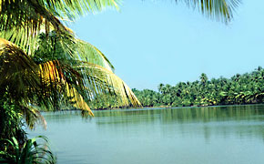
Verdant, rolling
landscape, with numerous brooks, cascades and breathtaking waterfalls,
Vellari Mala offers is a true abode for you to unwind and to immerse in the
whiff of its limitless fresh air. River Kanjirapuzha, a tributary of the
River Chaliyar, meanders through the rocky terrain, creating cascades and
breathtaking waterfalls at many points. The land's beauty and topography is
truly a trekker's paradise and is also an ideal picnic spot for people of
all age group to have a good
time.
Iringal
The famous son of
Iringal, Kunjali Marakkar went on to become the trusted admiral and
commanded the Zamorin's fleet and thwarted the efforts of Portuguese vessels
trying their best to make a landing on the Kerala coast. The birthplace of
this valiant admiral of the Zamorin is situated on the southern bank of the
Mooradi River. Today, Keralites remember his valour and selfless service
rendered for his motherland with lot of reverence.
The
Department of Archaeology took over his birthplace for preserving and also
to give an opportunity for generations to come and pay respect to one of
Kerala's valiant sons.
Getting
there:
Nearest Railway Station:Vadakara
Nearest
airport: Karipur International Airport, Kozhikode about 23 km from
Kozhikode town.
|
| Wayanad |
|
 |
Area: 2132 sq. km
Population: 671, 195 (2001 census)
Altitude: 700 - 2100 m above sea level
A bio-diverse region spread across 2,132 square kilometers on the
lofty Western Ghats, Wayanad is one of the view districts in Kerala that
has been able to retain its pristine nature. Hidden away in the hills
of this land are some of the oldest tribes, as yet untouched by
civilization. And the very first prehistoric engravings in Kerala
discovered in the foothills of Edakkal and around Ambukuthimala bear
testimony to a prehistoric culture dating back to the Mesolithic Age.
Strikingly scenic, it is known for its sub-tropical savannahs,
picturesque hill stations, sprawling spice plantations, luxuriant
forests and rich Cultural traditions. A holistic confluence of
wilderness, history and culture, Wayanad is located on the southern tip
of the magnificent Deccan plateau.
Nearest airport: Kozhikode
Nearest railway station: Kozhikode
Major towns in the district and distance from the nearest railway station:
Kalpetta: 72 km from Kozhikode
Mananthavady: 80 km from Thalasseri /106 km from Kozhikode
Sulthan Bathery: 97 km from Kozhikode
Vythiri: 60 km from Kozhikode.
Road: Well connected by roads from Kozhikode, Kannur, Ooty (175 km from Kalpetta) and Mysore (140 km from Kalpetta). |
| Neelimala |
|
|

Some of the beautiful things in life
come with a price tag. And this month we take you to witness and savour
one of Kerala's immaculate sights in the hill district of Wayanad. Of
course, it is a bit challenging for your legs. And the best time to be
there is just after the rains in June / July. By now, you might have got
a hang of what is in store? Yes, it has something to do with water. It
is just not water, but a milky way, tearing apart the dense greenery of
Wayanad forests. The Meenmutti waterfalls, gushing down and then flowing
in cascades further down its course is an awesome sight to watch from
the Neelimala viewpoint near Vaduvanchal in Wayanad.
Reach
Chundale before Kalpetta in Wayanad District and take the Ootty road to
the right that goes via Meppadi and on reaching Vaduvanchal turn right.
It is best to hire a four wheeler form here to reach Neelimala view
point. After three kilomteres drive from Vaduvanchal, the road turns to
the right and climbs up a rugged road to reach the base of a tribal
settlement, surrounded by coffee plantation and pepper vines. Get
down, pick your backpack, put on your trekking shoes and of course keep a
good camera.
On the way up to the Neelimala viewpoint, one
would have the company of the coffee plantations on either side and
further up, small holdings of ginger and areca nut. The sides of the
path leading to the view point is also dotted with small bushes of
purple flower plants and also chirping sun birds and other varieties of
small birds darting in and out of the bushes.
Completing the
first part of the ascend, which is about half a kilometer, the trekking
path gets narrower and goes down before it climbs up again. Now the
vegetation on the sides changes to tall, wild grass, including the lemon
grass variety. The narrow path goes further up and suddenly opens up
into a panoramic view, with the mountain folds of the Western Ghats on
your left and a hill slope replete with grass and studded with boulders
on the right. You have reached the Neelimala view point.
Have
a brief stop. Catch your breath. Feel the cool breeze in your hair, as
it dries out the sweat. Take a look around to spot some butterflies with
rare colour and size, gliding down the slopes and sometimes going
behind the mist. As you remain there, your ears slowly get receptive to a
rumble down the valley. If you hear it, take the narrow path going down
to the left. Make your way through tall grasses leaning on to you. Move
gently and watch out for slippery rocks and pits. Meandering to the
left, the path would lead you to a spot, where you would find yourself
standing behind a rocky spur with the rumbling noise becoming intense
manifold.
Carefully make your descend down and move towards the
middle of the rocky spur. It would take some time for you to believe
the mesmerizing sight that is right before you. Down flows a track of
white water, flanked by evergreen forests. A sight you would never
forget. Get your best shots and take in its pristine beauty as much as
you can. As you watch the unforgettable sight of Meenmutti waterfall, an
occasional blanket of thick mist could block your sight. But, do not
get upset. Wait for some time and as the mist clears out, and on
occasions the sheet of mist would split open to reveal the waterfall,
which is yet another delightful thing to watch.
Getting there:
Nearest railway station: Kozhikode, about 80 km from Vaduvanchal.
Nearest airport: Karipur International Airport, about 95 km from Vaduvanchal. |
| | |
|
No comments:
Post a Comment